DCMI Box Encoding Scheme
DCMI Box Encoding Scheme: specification of the spatial limits of a place, and methods for encoding this in a text string
| Creator: | Simon Cox |
|---|---|
| Contributor: | Andy Powell |
| Contributor: | Andrew Wilson |
| Date Issued: | 2005-07-25 |
| Identifier: | http://dublincore.org/specifications/dublin-core/dcmi-box/2005-07-25/ |
| Is Replaced By: | http://dublincore.org/specifications/dublin-core/dcmi-box/2006-02-13/ |
| Latest version: | http://dublincore.org/specifications/dublin-core/dcmi-box/ |
| Status of document: | This is a DCMI Proposed Recommendation. From 2005-07-25 to 2005-10-10, the status of this revision was incorrectly shown as "DCMI Recommendation".. |
| Description of document: | The DCMI Box encoding scheme is a method for identifying a region of space using its geographic limits. Components of the value correspond to the bounding coordinates in north, south, east and west directions, plus optionally up and down, and also allow the coordinate system and units to be specified, and a name if desired. A method for encoding DCMI Box in a text-string, as a profile of DCSV is described. This notation is intended for recording the value of the DCMES element Coverage, particularly when using HTML meta elements. |
Table of Contents
-
- Introduction
-
- Identifying a place - the DCMI Box scheme
-
- Encoding DCMI Box
- 3.1 DCSV encoding
-
- Examples
-
- References
1. Introduction
Several methods are available to indicate a place. These include, but are not limited to:
- a name , normally defined in an identifiable enumeration such as a gazetteer or list of jurisdictional localities;
- a unique geocode , such as a postal code;
- the coordinates of a point , using geographic values or some well-defined projection and units;
- a set of arcs or faces describing the polygon or polyhedron comprising the perimeter of the place;
- the limits of a regular shaped container which encompasses the place, typically a rectangular box in two or three dimensions, using geographic values or some well-defined projection and units.
The Dublin Core™ Metadata Element Set [DCMES] includes an element, Coverage , the value of which may be a reference to a place. If a name or geocode is used as the value for the property, then the scheme from which that is selected determines valid values. However, there are no simple, commonly used, notations for indicating a place using coordinates. Here we define DCMI Box, an encoding scheme which specifies the geographic limits of a place, and describe a method for encoding DCMI Box as a profile of DCSV [DCSV].
In the simplest usage, DCMI Box approximates the extent of a place using a container with a regular shape. For a more precise representation of an irregular shape it is possible to use the approach of "tiling" the place with a set of simple regions defined using DCMI Box. Alternatively, another notation describing a polygon or polyhedron may be used. If a value corresponding to a point is required, then DCMI Point [POINT] is available.
2. Identifying a place - the DCMI Box scheme
We identify a place by considering the minimal rectangular box which fully encloses the place, whose faces are aligned parallel with the axes of an identified cartesian coordinate system [Figure].
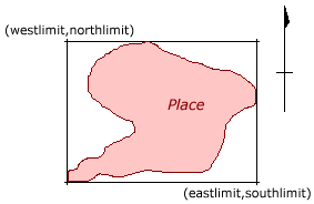
We define the following components to describe the box:
| Component | Definition | Default1 |
|---|---|---|
| northlimit | The value of the constant coordinate for the northernmost face or edge2 | INF3 |
| eastlimit | The value of the constant coordinate for the easternmost face or edge2 | INF3 |
| southlimit | The value of the constant coordinate for the southernmost face or edge2 | -INF3 |
| westlimit | The value of the constant coordinate for the westernmost face or edge2 | -INF3 |
| uplimit | The value of the constant coordinate for the uppermost face or edge2 | INF3 |
| downlimit | The value of the constant coordinate for the lowermost face or edge2 | -INF3 |
| units | The units applying to unlabelled numeric values of northlimit, eastlimit, southlimit, westlimit | signed decimal degrees |
| zunits | The units applying to unlabelled numeric values of uplimit, downlimit | metres |
| projection | The name of the projection used with any parameters required, such as ellipsoid parameters, datum, standard parallels and meridians, zone, etc | geographic coordinates on Earth for northlimit, eastlimit, southlimit, westlimit; height above mean-sea-level for uplimit, downlimit. |
| name | A name for the place4 | - |
**1***All components are optional. If any *limit component is absent, then this implies an interval unbounded on that side. Thus, a DCMI Box with a single component northlimit="0" would identify the entire southern hemisphere._
**2***Values are expressed as a text-string representing a number. Units should be included using conventional (SI) notation, unless the relevant units or zunits component is present. However, if units are given as part of any value, then for this component these override those given by units or zunits._
**3***If this component is absent then the value is undefined. Processors performing numeric comparisons are recommended to set values corresponding to maximally inclusive matching._
**4***In this context the name is non-normative. In the case of a conflict, the place identified by the coordinate values takes precedence. The name is provided for user convenience only._
3. Encoding DCMI Box
The components of a DCMI Box value have no meaning when disaggregated, since in any particular instance it is the complete set which acts to indicate the specific location. Thus, use of DCMI Box to indicate a place requires that the components are linked together. For systems in which data is encoded using a limited character set, this is conveniently accomplished by packaging the components into a single text-string according to the DCSV [DCSV] recommendation.
3.1 DCSV encoding
Writing DCMI Box using DCSV notation is straightforward, using the component names defined above. A DCMI Box value appears as follows:
northlimit=v1; eastlimit=v2; southlimit=v3; westlimit=v4; uplimit=v5;
downlimit=v6; units=v7; zunits=v8; projection=v9; name=v10
where v1 - v10 are values as defined in the table above.
All components are optional but must not be repeated, and the ordering is not significant.
4. Examples
Western Australia:
name=Western Australia; northlimit=-13.5; southlimit=-35.5;
westlimit=112.5; eastlimit=129
Lake Jindabyne:
northlimit=5980000; westlimit=644000; eastlimit=647000; southlimit=5966000;
units=m; projection=UTM zone 55 south
The Western Hemisphere:
westlimit=180; eastlimit=0
The Tropics:
northlimit=23.5; southlimit=-23.5
A mine, illustrating the use of 3-D coordinates:
northlimit=-21.3; southlimit=-21.4; westlimit=139.8; eastlimit=139.9;
uplimit=400; downlimit=-100; name=Duchess copper mine
5. References
[DCMES]
1999. Dublin Core™ Metadata Element Set, Version 1.1: Reference Description
http://dublincore.org/specifications/dublin-core/dces/
[DCMI]
Dublin Core™ Metadata Initiative, OCLC, Dublin Ohio.
http://dublincore.org
[POINT]
S. Cox, 2000. DCMI Point - a point location in space and methods for encoding this in a text string
http://dublincore.org/specifications/dublin-core/dcmi-point/
[DCSV]
S. Cox, R. Iannella, 2000. A syntax for writing a list of labelled values in a text string
http://dublincore.org/specifications/dublin-core/dcmi-dcsv/
[XML]
Extensible Markup Language
http://www.w3.org/XML/